LandClass/Vector Data

Any issues, problems or troubleshooting topics related to the Prepar3D client application.
Mischung
Posts: 17
Joined: Sat Dec 07, 2013 6:35 pm

Re: LandClass/Vector Data

Post by Mischung »

niksan29 wrote: Fri May 29, 2020 3:26 pm +1
WMSA, is necessary remove the never-existing ILS for runway 33.
Hey niksan,

sorry to say that, but WMSA had an ILS for RWY 33 (at least in cycle 1713):
Image

I think the current navdata of P3D-V5 are based on an AIRAC-cycle of the year 2017.
In my opinion it would be best to keep it consistent at this state and not do partial updates of the navdata.

One should do these updates manually, using Herve Sors' tools or using the fsAerodata-addon.

It would be absolutely great to have an updatable navdata-base in P3D, but I don't know the plans LM has on this topic.
Unfortunately updating the navdata is a real problem for us users.

Cheers,

Marc
niksan29
Posts: 144
Joined: Wed Aug 12, 2015 4:14 pm

Re: LandClass/Vector Data

Post by niksan29 »

Mischung wrote: Sat May 30, 2020 7:11 pm sorry to say that, but WMSA had an ILS for RWY 33 (at least in cycle 1713):
Hello!
lol, and why you not use even more older data? actual cycle 2006 not 1713...
in new cycles ILS 33 rwy not and this is the only right decision to remove it!
Mischung wrote: Sat May 30, 2020 7:11 pm In my opinion it would be best to keep it consistent at this state and not do partial updates of the navdata.
stay in the past if you like it, this is your opinion...
Mischung wrote: Sat May 30, 2020 7:11 pm It would be absolutely great to have an updatable navdata-base in P3D, but I don't know the plans LM has on this topic.
+1 here I absolutely agree, just create an external base which will be updated every month from Navigraph.
In the meantime, we can use the wonderful free update nav pack and tools from aero.sors.fr
Cheers!
Mischung
Posts: 17
Joined: Sat Dec 07, 2013 6:35 pm

Re: LandClass/Vector Data

Post by Mischung »

Hey niksan,

haha, I know what you mean, but I think you got me wrong :)

Of course I would really like to have up to date navdata in the sim, but this would be only possible if LM is implementing an updatable database as desrcibed. That would be the best solution!

But if we are updating only some of the navdata, like deleting ILS/LOC in WMSA or SBRJ, we would get an incosistent database, which is not a good state in my opinion - of course this is just an opinion :)
This would be a mixed navdata-base from 2017 with some updates from 2020.

In my case I don't really need the latest navdata update in the sim, but I want an overall consistent navdata-set (also using the same AIRAC in all my addons) - otherwise flight-planning will not really work.

At the moment I am considering the following options:
1) Wait for the HF2 and then update the navdata (manually) to my currently used cycle 1911, which I have installed in all addons at the moment.
2) Wait for HF2 and then update (again manually) to the latest cycle available (e.g. 2006) and also update all my addons accordingly.

Hope you know what I mean. I'm more focussed on consistency, than on the latest update...I'm a bit tired of this all manual update process :)

Cheers!

Marc
niksan29
Posts: 144
Joined: Wed Aug 12, 2015 4:14 pm

Re: LandClass/Vector Data

Post by niksan29 »

Mischung wrote: Sun May 31, 2020 8:50 am but I think you got me wrong :)
I understood you, no matter what cycle you use, you should always check the data if you want realism.
The data will always be updated and everything needs to be checked manually you will not have rest just understand this...
Mischung wrote: Sun May 31, 2020 8:50 am This would be a mixed navdata-base from 2017 with some updates from 2020.
if we use the most up-to-date cycle for GPS\FMS\planning tool, then mixed data will be better for us than the only old ones...
Mischung wrote: Sun May 31, 2020 8:50 am deleting ILS/LOC in WMSA or SBRJ
nonexistent must to be remove, is not discussed...
although you will argue that it’s better for everyone to use the ancient cycle and so we will not suffer )))
lol, really why do everyone buy new jeppsen\navigraph cycles every month)))

The whole world of sims is trying to use only the latest nav data and it's silly to argue with this and ask to leave the old data...
I don’t want me to have non-existent ILS and nav aids, if you need it add it, you know how;)

and in general, why did you get the idea that now it exactly corresponds to the specific cycle? I think this is also mixed data and not specific cycle ...
Cheers!
Mischung
Posts: 17
Joined: Sat Dec 07, 2013 6:35 pm

Re: LandClass/Vector Data

Post by Mischung »

Think we will not reach an agreement on these points :)
niksan29 wrote:you should always check the data if you want realism
Yes, simulation means realism to a certain extend.
Having the latest navdata in sim is very realistic of course...but it is not needed for flying/training an ILS, VOR or other approach.

I don't have any subscription for navigraph or fsAerodata or any charts, because the sim is always lagging behind and we have to update manually. (fsAerodata is great, but not compatible with Aivlasoft's EFB2, so I don't use it)
From time to time I'm buying a new cycle and then try to update the sim navaids and install this cycle into all my addons...and I can stay there for years.

But that's my procedure and not yours, I understand that :)
niksan29 wrote:nonexistent must to be remove, is not discussed...
Unfortunately P3DV5 still is in the year 2017 regarding navaids and it will stay there for now...
Of course you can try to find out every single discrepancy and post it here, but this will be an endless fight and I don't know if it is really worth it.
niksan29 wrote: The whole world of sims is trying to use only the latest nav data and it's silly to argue with this and ask to leave the old data...
I would rather leave it at a specific cycle than to mix it up...the only practible way is to have a navaid-database, which we can easily get updates for.

Let's hope we will get something like this in the future and then I will also subscribe to have access to the Navigraph-charts again :)
niksan29
Posts: 144
Joined: Wed Aug 12, 2015 4:14 pm

Re: LandClass/Vector Data

Post by niksan29 »

Mischung wrote: Sun May 31, 2020 2:56 pm Having the latest navdata in sim is very realistic of course...but it is not needed for flying/training an ILS, VOR or other approach.
for training, yes it’s not particularly important, we can use the same data for years.
But to try to get closer to reality, new data are required.
---
Mischung wrote: Sun May 31, 2020 2:56 pm But that's my procedure and not yours, I understand that :)
yes you're right, your procedures are not like everyone else's, your procedures are to use ancient cycles for a long time, let Navigraph\Jeppssen no longer get a penny)))
---
Mischung wrote: Sun May 31, 2020 2:56 pm Of course you can try to find out every single discrepancy and post it here, but this will be an endless fight and I don't know if it is really worth it.
I don’t specifically do this when I make a flight plan I randomly notice this discrepancies, but you don’t notice it because you use ancient cycles, that's all
---
Mischung wrote: Sun May 31, 2020 2:56 pm I would rather leave it at a specific cycle than to mix it up...
see my answer above:
and in general, why did you get the idea that now it exactly corresponds to the specific cycle? I think this is also mixed data and not specific cycle ...
---
Mischung wrote: Sun May 31, 2020 2:56 pm the only practible way is to have a navaid-database, which we can easily get updates for.
yes it would be ideal, moreover, it is possible to implement for third-party scenary also use this database and not store it in third-party scenary
Cheers!
User avatar
Max Perry
Lockheed Martin
Posts: 524
Joined: Tue Sep 14, 2010 1:22 am

Re: LandClass/Vector Data

Post by Max Perry »

I removed it now!
Dexter1979
Posts: 9
Joined: Mon Dec 31, 2012 3:05 pm

Re: LandClass/Vector Data

Post by Dexter1979 »

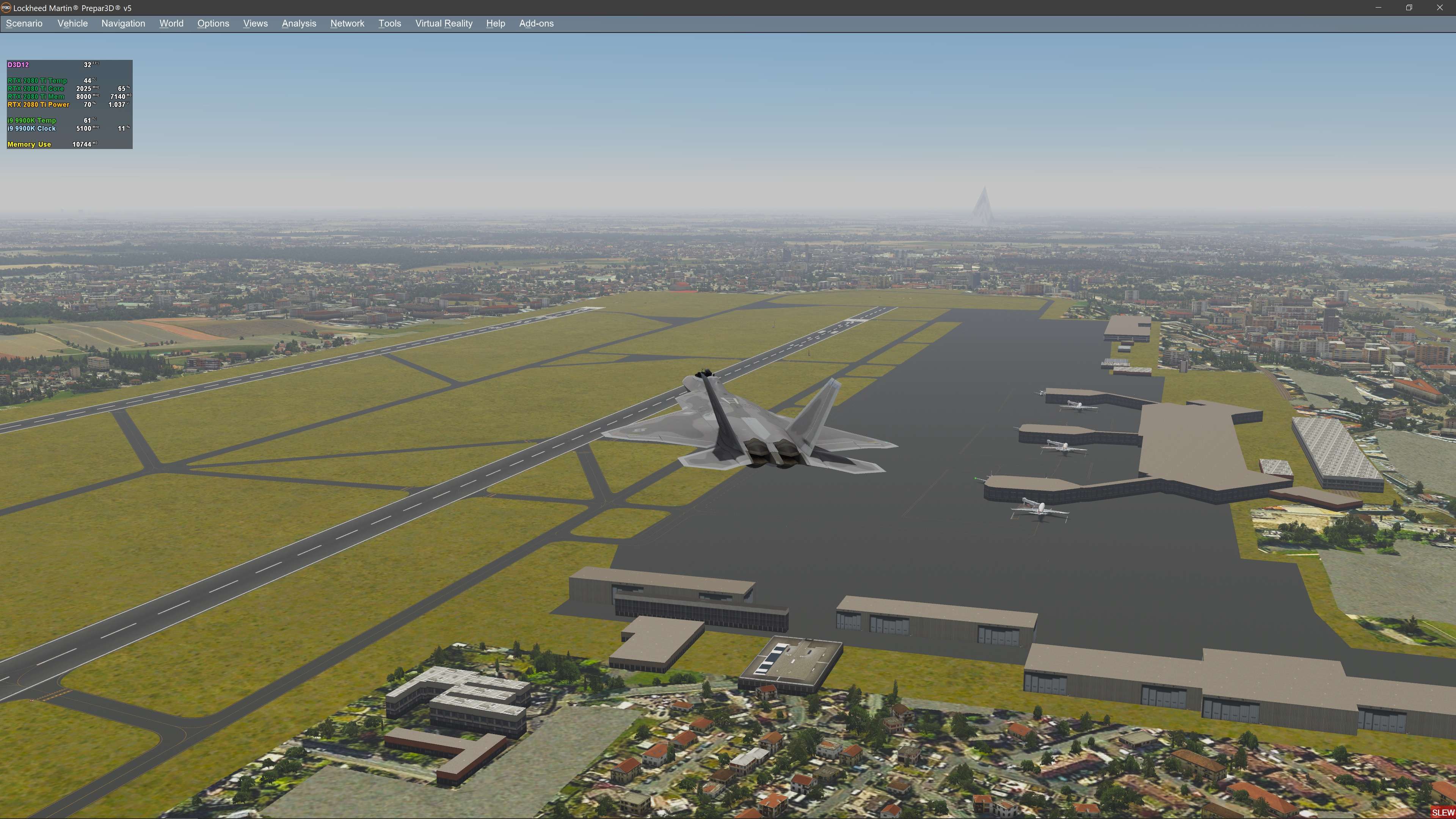
I've found another terrain issue near LIMC Milan...
Looks like a pyramid... :)

Image
niksan29
Posts: 144
Joined: Wed Aug 12, 2015 4:14 pm

Re: LandClass/Vector Data

Post by niksan29 »

Max Perry wrote: Mon Jun 01, 2020 3:11 pm I removed it now!
Thank you!
Max, wanted to ask you, any chances to add a missing LTFM(there is no airport at all)?
Dexter1979 wrote: Tue Jun 02, 2020 2:07 am I've found another terrain issue near LIMC Milan...
Looks like a pyramid... :)
+1
yes it is there:
Image
Cheers!
User avatar
Max Perry
Lockheed Martin
Posts: 524
Joined: Tue Sep 14, 2010 1:22 am

Re: LandClass/Vector Data

Post by Max Perry »

EDIT: LTFM is on the list for the future, that's a big one.

(Pyramid of water will be gone soon)
niksan29
Posts: 144
Joined: Wed Aug 12, 2015 4:14 pm

Re: LandClass/Vector Data

Post by niksan29 »

Cheers!
airbader
Posts: 157
Joined: Sun Sep 11, 2011 4:49 pm

Re: LandClass/Vector Data

Post by airbader »

Here's another vector issue south of Lake Charles, LA. https://imgur.com/a/3zPNzkx

Image
jabloomf1230
Posts: 262
Joined: Thu Nov 01, 2012 7:40 pm

Re: LandClass/Vector Data

Post by jabloomf1230 »

@Max Perry

Here's another minor update needed. The tower frequency in P3d5 for the stock EGKA (Shoreham, UK) is 125.400, when in fact, the real world airport uses the 8.33 KHz frequency of 125.405. Here's the official listing for EGKA:

https://www.aurora.nats.co.uk/htmlAIP/P ... #AD-2.EGKA

Note that various online unofficial sources like SkyVector, also have the incorrect tower frequency for EGKA of 125.400. I suggest that the official government navigation data be consulted for other airports that may be using the 8.33 KHz comm spacing.

Also, I contacted Navigraph support about EGKA and they are presently using 125.400 because they did not want to create an inconsistency with P3d5. The Garmin GTN 750 trainer, which is the basis for the most common advanced 3rd party gauges used in P3d (both Flight 1 and RXP versions) has the correct tower frequency for EGKA in its database, which is based directly on Jeppesen data.

Thanks
Post Reply