East Africa - Lake Cahora Bassa water surface elevation

Discussion related to terrain/scenery design.
Post Reply
PhilK
Posts: 85
Joined: Wed Oct 08, 2014 4:25 pm

East Africa - Lake Cahora Bassa water surface elevation

Post by PhilK »

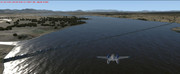
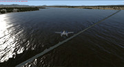
Completing some flights overs the East African Great Lakes,

Image

Image

Image

Image

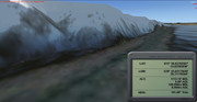
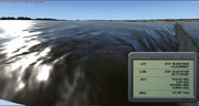
Wondering whether mesh (Toposim here), or other issue...

Blue skies!
Windows 10 x64, Z170A Gaming Pro Mobo, i7-6700K CPU (no O/C), 16 Gb DDR4 RAM, RTX3060 12 Gb, P3D v5.3.17, Toposim mesh, FTX Global Base, Vector, OpenLC EU, OpenLC North America, OpenLC South America, OpenLC Africa, Trees HD, ASP3D, ASCA
User avatar
Max Perry
Lockheed Martin
Posts: 524
Joined: Tue Sep 14, 2010 1:22 am

Re: East Africa - Lake Cahora Bassa water surface elevation

Post by Max Perry »

I'm fixing the lakes right now, thanks for calling this out it's further south than i had checked before.
PhilK
Posts: 85
Joined: Wed Oct 08, 2014 4:25 pm

Re: East Africa - Lake Cahora Bassa water surface elevation

Post by PhilK »

Great to read
Thank you, Max
Windows 10 x64, Z170A Gaming Pro Mobo, i7-6700K CPU (no O/C), 16 Gb DDR4 RAM, RTX3060 12 Gb, P3D v5.3.17, Toposim mesh, FTX Global Base, Vector, OpenLC EU, OpenLC North America, OpenLC South America, OpenLC Africa, Trees HD, ASP3D, ASCA
Post Reply